

OUR SERVICES
WE SURVEY
WE DELIVER
At AeroDrone Surveys, we provide accurate, reliable and efficient surveying solutions using advanced drone and geospatial technology. Our services help clients capture high-quality site data quickly, safely and with minimal disruption, providing the information they need to make confident decisions throughout every stage of their project.


A digital, auditable approach to recording highway conditions, defects and construction snags throughout your development.
Using our mobile app, site teams can capture photographs of specific issues and link them directly to the associated drone survey and site location. This creates a clear, time-stamped and traceable record of each item, from initial identification through to completion.
The collected information can then be used to produce professional reports for project teams, contractors, clients and third parties, providing clear evidence of site conditions and remedial works.
Highway Condition & Snagging Reporting.

Accurate site surveys that compare completed works against design, helping you monitor construction progress and identify discrepancies.
AeroDrone Surveys delivers clear, measurable data and visual records to support quality control, project management and client reporting throughout the construction process.
As-Built Checks & Progress Reporting

Accurate stockpile surveys providing reliable volume measurements for materials, aggregates and earthworks.
Using drone-based aerial surveying and high-precision positioning, we capture detailed data across stockpiles which can be used to calculate material volumes, surface areas and changes over time. Regular surveys can help you monitor inventory levels, track material usage and identify gains or losses between survey periods.
Ideal for quarries, construction sites, aggregate suppliers, waste management facilities and material storage areas, our stockpile surveys provide a fast, safe and repeatable alternative to traditional methods.
Whether you need a one-off stocktake or regular monitoring, AeroDrone Surveys delivers clear, accurate data to help you manage projects with confidence.
Stockpile Surveys
Aerial Surveys

Accurate, detailed surveys providing the reliable site data you need to plan and deliver with confidence.
Using high-precision drone technology, RTK positioning and advanced survey processing, we capture the existing terrain, levels, features and structures across your site.
Our surveys can provide detailed point data, contours, digital terrain models and other CAD-ready outputs to support architects, engineers, developers and construction teams.
From initial site appraisal through to detailed design and construction,
AeroDrone Surveys delivers clear, measurable data that gives your project a reliable foundation.
Earthworks Data

Accurate drone survey data to help you understand material movement, site progress and project quantities.
Using drone-based aerial surveying and high-precision data capture, we provide detailed data for cut and fill areas, excavations, embankments, stockpiles and material movements.
Our reliable, repeatable surveys give you the data you need to produce your own volumetric calculations, monitor progress and manage materials throughout the project.
Whether you're checking formation levels, monitoring earthworks against design or calculating material quantities, AeroDrone Surveys provides accurate survey data you can rely on.
Hydraulic Insights
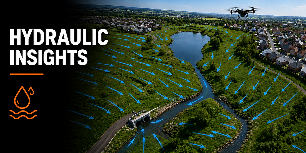
Detailed hydraulic mapping to help you understand how water moves across a site and support informed drainage, flood-risk and infrastructure decisions.
Using high-precision drone surveying and accurate terrain data, we capture the features and levels that influence surface water movement, including ditches, channels, culverts, watercourses, ponds, drainage infrastructure and surrounding ground levels. Our data can be used to identify flow paths, low points, catchment areas and potential areas of surface-water accumulation.
Whether supporting new developments, drainage design, flood assessments or infrastructure projects, AeroDrone Surveys provides clear, accurate site data to help engineers and consultants understand existing hydraulic conditions.

Change Monitoring
Track and document site changes over time using repeatable drone surveys and accurate data capture. Compare survey data from different dates to identify changes in ground levels, earthworks, stockpiles, construction progress and site conditions.
Create a reliable historical record that helps you monitor progress, investigate changes and provide clear, auditable evidence when needed.